Stone Mound Investigations as of 2009
Norman E. Muller
Introduction
For the past twelve years, I have been deeply involved in the study of
aboriginal stone constructions. Others, such as Fred Werkheiser of
Bethlehem, Pennsylvania, who first introduced me to this
fascinating subject, have been at this much longer. The field has a
small but enthusiastic group of researchers, most of whom regularly
post photographs and commentaries of what they have found on their
numerous excursions. Peter Waksman (https://rockpiles.blogspot.com)
comes to mind as one who has been at this the longest. Others who
maintain interesting websites and blogs are Doug Schwartz
(https://nativestones.com),
James and Mary Gage
(https://stonestructures.org),
Tim MacSweeney
(https://wakinguponturtleisland.blogspot.com),
Larry Harrop
(Gallery),
David Schewe
(https://hi-torstone.blogspot.com),
and Kathy Klopchin
(https://twoheadwaters.blogspot.com).
 All this activity has been fostered by the availability of
inexpensive digital cameras, and by rapid communication and posting of
images via the Internet. Whereas before a smattering of
sites was fairly well known to active researchers, now there are dozens, and
the list keeps growing. By categorizing certain features, as
Harrop has done on his website, we now know that certain types of carefully made
stone structures, such as platform cairns, are
widespread throughout the Northeast. Although many professional archaeologists
still claim they were constructed by colonial farmers, the distribution of these
visually impressive features, and the fact that they appear to have no
agriculturally related function or any mention in the historical
record, suggest that they have a significance we are not yet aware of,
and that we need to look at them and other unusual stone
constructions
and accents more closely and seriously.
All this activity has been fostered by the availability of
inexpensive digital cameras, and by rapid communication and posting of
images via the Internet. Whereas before a smattering of
sites was fairly well known to active researchers, now there are dozens, and
the list keeps growing. By categorizing certain features, as
Harrop has done on his website, we now know that certain types of carefully made
stone structures, such as platform cairns, are
widespread throughout the Northeast. Although many professional archaeologists
still claim they were constructed by colonial farmers, the distribution of these
visually impressive features, and the fact that they appear to have no
agriculturally related function or any mention in the historical
record, suggest that they have a significance we are not yet aware of,
and that we need to look at them and other unusual stone
constructions
and accents more closely and seriously.
 There was once the strongly held belief
that our Indian forebearers lived lightly on the land and left no
visible permanent record of their existence. For the most part that is
true, but if one takes a stroll through the rocky terrain of Rhode
Island, as Larry Harrop has done repeatedly over the past five years or
more, one will encounter a bounty of impressive above-ground stone
constructions -- artifacts really -- most of which were probably
made by American Indians over the thousands of years they occupied the land.
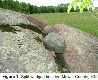
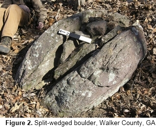
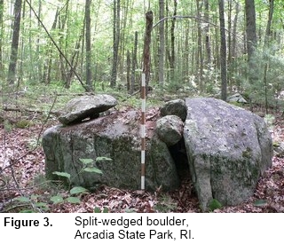
Some of these, such as split-wedged boulders, are
like a signature or a sign that one is entering terrain where one is bound to find
additional examples of Indian stone handiwork. Split-wedged boulders
have been found from Minnesota (Figure 1)
to Georgia (Figure 2) and up to
New England (Figure 3), attesting
to their widespread aboriginal origin.
There was once the strongly held belief
that our Indian forebearers lived lightly on the land and left no
visible permanent record of their existence. For the most part that is
true, but if one takes a stroll through the rocky terrain of Rhode
Island, as Larry Harrop has done repeatedly over the past five years or
more, one will encounter a bounty of impressive above-ground stone
constructions -- artifacts really -- most of which were probably
made by American Indians over the thousands of years they occupied the land.
Some of these, such as split-wedged boulders, are
like a signature or a sign that one is entering terrain where one is bound to find
additional examples of Indian stone handiwork. Split-wedged boulders
have been found from Minnesota (Figure 1)
to Georgia (Figure 2) and up to
New England (Figure 3), attesting
to their widespread aboriginal origin.
Research in the Northeast
Unfortunately, progress in answering the question of who
constructed the mysterious stone features of the Northeast took a
detour when William B. Goodwin published a rambling book in 1946 on the
stone ruins supposedly built by Celtic explorers to New England.[1]
Goodwin compared the construction of some stone features in New England
with Celtic ruins in Ireland, concluding that the New England examples
were constructed by Celts around the eighth century. Goodwin's book was
followed up several decades later by several popular books on much the
same theme by Barry Fell, a retired Harvard University marine
biologist.[2]
Fell got no closer to proving his case than Goodwin, and
both incurred the wrath of the archaeological community, which
concluded that all of this was simply "fantastic archaeology", meaning
tales of fiction without much value.[3]
James Mavor and Byron Dix in
their book Manitou, published sixteen years after Fell's last book,
[4]
took a different view of the stone ruins in New England and
pronounced
them to be American Indian, but their emphasis on celestial and
astronomical alignment of walls and chambers, while appealing to more
reasonable people, still failed to impress the archaeological
establishment. Even now, serious and even-handed researchers are
frequently lumped together with those who espouse a more radical
interpretation of our ancient past. A good example of where the
situation stands is found in a curious and rather unpleasant commentary
tucked at the back of the newsletter Terra
Firma #5, published in 2007
by the Massachusetts Department of Conservation and Recreation's
Historic Landscape Preservation Initiative. In a book titled "The Last
Word: Debunking the Myth of Stone Walls, Piles and Chambers," the
anonymous author wrote the following:
"The stone walls built by New
England farmers helped define property lines, divide fields, woodlots
and pastures, and shape animal pens. Coincidently, the walls may match
cardinal compass points or celestial phenomena, but for practical
purposes rather than sacred. It was also common to construct cold
cellars and pile surplus rocks within pastures for later use or sale.
Some have suggested a Native American origin for these features.
There is no archaeological evidence to support this conclusion. When
historians and archaeologists have researched stone walls, piles and
chambers, they have invariably demonstrated that these features are
associated with the activities of European settlers and have no Native
American (or other) origin. In addition, Native American advisors have
been involved in a number of excavations and have confirmed these
findings. However, archaeologists do find stone features on Native
American sites, hearths for example. But they rely on context to make
the determination where, during a controlled scientific excavation,
archaeologists analyze the entire site, all artifacts associated with
the feature, and its placement in the soil. This provides the cultural
and geological context needed to interpret and date the entire site.
Archaeologists also consider ethnographic and ethnohistorical
information. For example, Native American oral traditions record that
people did place small stones or twigs on a sacred spot as they passed
by. Over time this might result in a small pile of pebbles, tiny
cobbles, or sticks, but not large piles. Conversely there is a strong,
documented ethnohistory of stone building traditions among the European
settlers of Massachusetts. Together, archaeology and ethnohistory
provide conclusive evidence that stone walls, piles and chambers are
not the work of ancient cultures.
[5]
What the author of "The Last Word" did not realize in his
or her myopic view of possible Indian stone construction, is how much
progress has been made not only in New England, but specifically in the
South over the past forty years or so in determining whether stone
piles and walls are colonial or aboriginal. A review of some of the
documents discussed below could give added impetus in moving discussion
away from a total denial of Indian manufacture for certain walls and
cairns to something approaching open-mindedness.
As one who has researched stone cairns, walls and other unusual
man-made or altered stone features in the Northeast and beyond for more
than a decade, I can say in all truthfulness that I have no solid
factual evidence establishing who made or altered these features, when
they were made, or what purpose they served. I have argued in several
articles that by comparing certain types of features to others having
similar morphology, a pattern of design can be established, one that
suggests a commonality of purpose.
Such an argument was presented in an article I wrote about the
Oley Hills site in eastern Pennsylvania, [6]
where the pattern and
distribution of walls and cairns seemed to focus on a huge boulder or
stone tor on the summit of a hill, which I concluded was the main
reason for the construction of the wall and cairns. The placement and
focus of these features on the landscape seemed clear and convincing,
but not to some readers of the article, presumably because no hard
evidence was presented supporting the main thesis.
After the article was published and critical comments were
received and digested, I concluded that however careful one is in
formulating an argument based primarily on empirical evidence, if no
hard evidence in the form of potsherds, charcoal for radiocarbon
dating, or other cultural debris found in an archaeological context is
presented supporting one's viewpoint, one is simply left with an
argument that is difficult, if not impossible, to justify. Since the
point of this research was intended to advance knowledge, then it was
simply not good enough. If we are to move forward in answering the
age-old questions of, "Who made it?, When was it made?, and Why?" we
must embrace archaeological methodology, invite archaeologists to work
with us, and move toward a common goal of cooperation and understanding.
Stone Wall and Stone Mound Research in the South
For reasons that are not entirely clear, for decades
archaeologists in the South have been more open to the idea that
Indians were responsible for some of the stone features
found there.
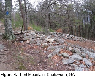
Part of this may be due to the fact that when the region was first
settled, pre-existing stone features on the landscape, such as the
curious serpentine wall near the summit of Fort Mountain in northwest
Georgia, were recorded (Figure 4).
[7]
Then there were mavericks such as Arthur R. Kelly, legendary
archaeologist and founder of the Department of Anthropology at the
University of Georgia in 1947, who had an open mind about cairns and
other stone features he had come across. Kelly had long been interested
in unusual stone walls and enclosures he had encountered. He encouraged
Philip E. Smith, a graduate student in archaeology at Harvard
University, to undertake a survey of aboriginal stone constructions in
Georgia and surrounding states. Smith's report, published in 1962, was
titled "Aboriginal Stone Constructions in the Southern Piedmont," and
was based on a survey conducted over two summers in 1955-56.[8]
At the
end of his article, Smith concluded that the walls he studied seemed to
tie together large boulders and outcrops, and in certain instances made
deliberate detours to connect with boulders (Figure 5). Because of
this, Smith raised the possibility that the main reason for the walls
was to link "certain impressive natural phenomena such as boulders or
bluffs which may have held some religious, symbolic or animistic
significance to the people concerned." [9] Smith's
seminal article has
been an inspiration to many researchers, including myself.
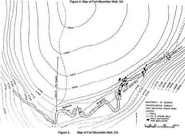
Finding no cultural artifacts during his two year investigation,
Smith recognized the weakness of his research, in that it was
ultimately based on hunches and not on hard evidence, and that he was
no closer in getting to the real meaning of the structures at the end
of his research than he was at the beginning. But by presenting the
comparative evidence that he had accumulated, he hoped that it would
serve as the "jumping-off point for future investigation." Hard research would come not from the examination of walls and
enclosures, but from stone mounds, since they often represented
burials. They also presented problems of cultural origin and date ever
since they were first encountered. Serious research on stone mounds in
the South, and whether or not they were aboriginal or colonial, began
in 1978 with the publication of two articles: one by Fish, Fish and
Jeffries,[10] and the other by Jeffries and Fish.[11]
The former had a
section titled "The Stone Mounds: A Need to Explore an Archaeological
Mystery." Beginning with a survey of historical references to stone
mounds, the authors concluded with the statement: "Previous research
concerning stone mounds has demonstrated that their nature and origin
cannot be satisfactorily determined using surface appearance and
location as the sole criteria." [12]
That most of the cairns in the South were probably colonial or
later was the subject of a study by Thomas Gresham in 1989,[13]
which was
an indirect criticism on an archaeological survey of the
Parks-Strickland cairn site in Gwinnett County, Georgia, undertaken by
Patrick Garrow and David W. Chase in 1988.14
Garrow and Chase concluded
that the dozens of cairns on the site were probably not historic
because of five factors:
-
The mound complexes are located
on the only level ground in the vicinity, which would have been most
suitable for farming.
-
The mounds straddle a property line but are also perpendicular
to this line, whereas historic stone piles are almost invariably
parallel to property lines to minimize the amount of area wasted to
stone disposal.
-
The land was never cultivated, and the nearest cultivated land
is separated from the mound complexes by steep slopes.
-
The mounds were carefully planned and constructed. "There is
simply no logical reason why a farmer would have expended that much
labor to construct stone mounds that had no other conceivable
function."
-
5. Mounds were not randomly placed and occur at equal distances from
each other on parts of the Strickland Mound Complex.[15]
Because of its seemingly over reliance on observation and logic,
Gresham would not accept Garrow's conclusions,[16]
and thus began a long
drawn-out controversy between the two protagonists, with Gresham
arguing for archaeological digging to determine the cultural origin and
date of the mounds, and Garrow repeating his arguments based mainly on
a visual and logical analysis of cairn sites.[17]
Gresham countered with
an archaeological survey of the Strickland Tract, during which he
opened five cairns and found cultural artifacts from the nineteenth
century in two of them. On the basis of this, he concluded that all the
cairns at the site were probably historic, even though the other three
did not produce any definitive diagnostic material.[18]
 Within the past seven years, a few careful excavations,
several of which have occurred at a single site, have resulted in one cautionary
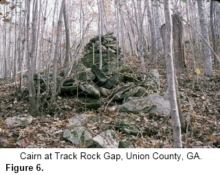
tale, important observations, and discoveries. In 2002, Johannes
Loubser and T.G. Grenier produced a report on a site in Track Rock Gap
in north central Georgia.[19]
This site, on the east side of the Gap,
consists of dozens of terrace walls and cairns that had been earlier
discovered by Carey Waldrip, a resident of a nearby town, Blairsville
(Figure 6). Loubser dated one
wall by removing soil underneath it and
having it tested using oxidizable carbon ratio (OCR). The date obtained
was ca. 1075 b.p.[20] Nearby,
a 4.5m x 3m x .7m stone mound on a high
promontory was excavated. Two column-shaped rocks were lying on the
south side of the pile which Loubser interpreted might once have "stood
upright in a monolith fashion." After removing the top layer of stones,
Loubser uncovered diagnostic artifacts underneath that confirmed the
accuracy of the OCR date for the wall.
Within the past seven years, a few careful excavations,
several of which have occurred at a single site, have resulted in one cautionary
tale, important observations, and discoveries. In 2002, Johannes
Loubser and T.G. Grenier produced a report on a site in Track Rock Gap
in north central Georgia.[19]
This site, on the east side of the Gap,
consists of dozens of terrace walls and cairns that had been earlier
discovered by Carey Waldrip, a resident of a nearby town, Blairsville
(Figure 6). Loubser dated one
wall by removing soil underneath it and
having it tested using oxidizable carbon ratio (OCR). The date obtained
was ca. 1075 b.p.[20] Nearby,
a 4.5m x 3m x .7m stone mound on a high
promontory was excavated. Two column-shaped rocks were lying on the
south side of the pile which Loubser interpreted might once have "stood
upright in a monolith fashion." After removing the top layer of stones,
Loubser uncovered diagnostic artifacts underneath that confirmed the
accuracy of the OCR date for the wall.
A good example of the problems and potentialities in
investigating stone mounds is found in two reports that concern a stone
mound site in Greene County, Georgia. In 2004, Jerald Ledbetter,
working for Southeastern Archaeological Services, Inc. conducted a
survey of site 9GE2084, which consists of a concentration of rock piles
in Greene County, Georgia, 14km south-southwest of Greensboro, and
located on a knoll above a creek.[21] Nineteen
distinct rock piles were
identified, five of which were labeled A-E. Based on a horseshoe
recovered from one of four shovel test pits, Ledbetter initially
proposed that all the cairns at the site represented historic field
clearing piles. But critical comments by several reviewers stating that
his conclusion was not backed up by sufficient evidence, made him
return to the site for Phase II, during which he and his staff
undertook a more comprehensive excavation of the other cairns.[22]
Excavations during Phase II in 2005 were much more
comprehensive, in that an additional 37 shovel test pits were excavated
across 9GE2084. Eight of the test pits yielded artifacts. A trench
measuring 4m long by 1m wide was cut through Pile C, and in that trench
they uncovered human teeth and bones, plus ancient pottery fragments
attesting to an Indian burial. Additional cultural remains were
uncovered in Pile E, but not in Piles A and F, which were thought to be
historic in date. Ledbetter also employed the services of a
geomorphologist, David Leigh, Ph.D., and concluded that:
"The prehistoric rock mounds were
found to have a finer overall particle size and larger proportion of a
fine (<2mm) organic and mineral matrix material between the stones.
Pebble counts ... demonstrate that the prehistoric mounds have a smaller
average particle size when compared to the historic mounds.... The
historic mounds contain few rocks smaller than 5cm, whereas <5cm
cobbles are common in the prehistoric mounds. Leigh concluded that the
smaller rock size, fine organic-rich matrix, and lack of plow zones
beneath and around Mounds C and E are all convincing pieces of evidence
that support the prehistoric age assignment."
[23]
Having examined the piles in greater detail than during the initial
excavation, Ledbetter concluded, under the section "Revised Conclusions
and Recommendations," the following:
"Our original interpretation that
site 9GE2084 was composed of an extensive scatter of agricultural rock
piles is clearly in error. The site contains one rock mound of
confirmed prehistoric origin (Rock Pile C) and a second of probable
prehistoric construction (Rock Pile E). Excavation data from two other
piles (Rock Pile A and Rock Pile F) provided data comparable to that
used by other researchers as evidence of historic construction.
Characteristics used to identify historic piles include size and shape
(relatively small size of pile and elongated appearance suggestive of a
wagon load), construction with larger rocks (Rock Piles A and F lacked
the smaller rocks found in Rock Piles C and E), placement of the piles
on a ground surfaces that appears to have been cultivated, absence of
prehistoric cultural remains beneath the pile. Other more subjective
observations of more recent construction include piles that are
relatively high in proportion to width, rocks that are loosely packed
with little or no soil accumulation between rocks, and little evidence
of weathering, discoloration or staining resulting from long term moss
or lichen cover. If correct in our current interpretations, 9GE2084
contains rock piles constructed during both prehistoric and historic
times."
[24]
Because a residential development was slated for the area around
the site, additional excavations were suggested to determine whether
any of the other cairns were prehistoric. Johannes Loubser was the
principal investigator of this Phase III excavation.[25]
His observations confirmed the following:
"Overall then the message of this
brief tour to other geographic areas is that a look below the surface
is imperative; materials remain and behaviors are not always what they
appear to be on the outside. For this reason then it seems unlikely
that relying solely on surface inspections or on our own
pre-conceptions would yield conclusive answers; excavation of one kind
or another, together with consultation of ethnographic sources, are
currently the only ways to properly assess rock piles."
Finally, under the heading "4.1
Research Questions and Design" Loubser concludes with:
"straightforward typologies, based
on surface criteria, such as location, size, morphology and layout,
have not always been conclusive or convincing [Loubser then refers to
reports by Garrow (1994) and Gresham (1990) among other authors]"Only
an investigative strategy that involves some kind of sub-surface
sampling can address questions pertaining to the stratigraphic
association, age, physical and chemical makeup, and cultural
affiliation of the rock piles and associated soil
deposits' stratigraphic association can reveal a lot about the antiquity
of a rock pile, particularly the vertical association between a rock
pile and a plow zone. Plowing is a special perturbation that
effectively homogenizes the included soils "If the bottom of a pile lies
on top of or within a plow zone, then the rock pile is historic in
date. If, however, the rocks penetrate well below the plow zone,
especially into deposits with prehistoric artifacts or charcoal with
prehistoric radiocarbon dates, then the rock pile is most probably
prehistoric in date."
Written and photographic
documentation of cairns, walls and other unusual and impressive stone
features, in addition to historical research and deed search, should
certainly continue to be done. This is basic to any research, even
archaeological. And, unfortunately, cairns and other man-made stone
features that rest on bedrock or boulders cannot at this time be
accurately dated by any means currently known. But for those cairns and
stone piles that rest on soil, the examples above can serve as a guide
to finally answering who built these perplexing stone features, and
when.
This article was previously published in the NEARA Journal,
volume 43 number 1, Summer 2009, p.17.
Notes
[1]
Goodwin, William B. The Ruins of Great Ireland in New England. Boston 1946.
[2]
Fell, Barry. America B.C., NY 1976; Bronze Age America, NY 1982; Saga America, NY 1983.
[3]
Williams, Stephen. Fantastic Archaeology: The Wild Side of North American Prehistory. Philadelphia 1991.
[4]
Mavor, James W., Jr. and Byron M. Dix. Manitou: The Sacred Landscape of New England's Native Civilization. Rochester, VT, 1989.
[5]
The author obviously failed to mention the wall under the drip line
of the Flagg Swamp Rockshelter in Marlborough, Massachusetts, that was
excavated by archaeologists from Harvard University in 1980, who dated
it to 4750 B.P. Unfortunately, it was in the way of a planned off ramp
to a highway, and as John Hanson Mitchell relates in his marvelous book
Ceremonial Time: Fifteen Thousand Years on One Square Mile (New York
1984, 64), "the construction crews returned, holes were drilled in the
rock face, and five thousand years of history was dynamited into
oblivion." Another omission was the large commemorative Indian stone
pile below Monument Mountain in Stockbridge, Massachusetts, that was
sketched by Ezra Stiles in 1762 (the drawing is reproduced in Eva L.
Butler, "The Bush or Stone Memorial Heaps of Southern New England,"
Bulletin of the Archaeological Society of Connecticut (April 1946),
2-12). Although the present mound is not thought to be the one drawn by
Stiles, such a large commemorative stone mound belies what the
anonymous author wrote in the statement.
[6]
Muller, Norman E. "Accenting the Landscape: Interpreting the Oley
Hills Site," Chapter 10 of The Archaeology of Semiotics and the Social
Order of Things, George Nash and George Children, eds., BAR
International Series 1833, Oxford 2008, 129-140.
[7]
The earliest reference to the wall was made by George White,
Statistics of the State of Georgia, Savannah, 1849, 442. This is also
mentioned in P.E. Smith, "Aboriginal Stone Constructions in the
Southern Piedmont," University of Georgia Laboratory of Archaeology
Series, Report No. 4, Part II, Athens, Georgia, 1962, 10.
[8]
Smith_Aboriginal_Stone_Constructions_UGA_Lab_Series_04.pdf.
[9]
Smith, P.E., 34-35.
[10]
Fish, Suzanne K, Paul R. Fish and Richard W. Jeffries. "An
Examination of Interfluvial Settlement in the Georgia Southern
Piedmont: The Georgia Power Company Plant Scherer Archaeological
Survey," University of Georgia Laboratory of Archaeology Series Report
No. 15, (1978).
Fish_Stone_Mounds_UGA_Lab_Series_15.pdf.
[11]
Jeffries, Richard W. and Paul R. Fish. "Investigation of Two Stone
Mound Localities, Monroe County, Georgia," University of Georgia
Laboratory of Archaeology Series Report No. 17 (1978).
Jeffries_Two_Stone_Mound_Localities_UGA_Lab_Series_17.pdf.
[12]
As in n6, 36.
[13] Gresham,
Thomas H. "Historic Patterns of Rock Piling and the Rock
Pile Problem," Early Georgia 18 (1989), 1-40.
gresham_historic_rock_piling.pdf.
[14]
Garrow, Patrick H. and David W. Chase. Archaeological
Investigations
of Two Stone Mound Complexes in Gwinnett County, Georgia, 75 page
report published under the auspices of Garrow & Associates, Inc.,
Atlanta, Georgia (1988).
[15]
Ibid, 52-53.
[16]
Gresham (as in n.9), 24-25.
[17]
Garrow, Patrick H. Archaeological Investigations at the Headwaters
of the Apalochee River: An Intensive Survey of the Dacula Tract,
Gwinnett County, Georgia. Garrow & Associates, Inc., June 1990.
Garrow, P.H., The Gwinnett Stone Mounds. 31 page report published under
the auspices of Garrow & Associates, Inc., Atlanta, Georgia (1994).
This controversy was also briefly discussed in N. Muller's "The Cairns
in Our Midst: Historic or Prehistoric," NEARA
Journal, 37 (2), Winter 2003, 7-8.
[18]
Gresham, Thomas H. Archaeological Investigations of the Strickland
Tract, Gwinnett County, Georgia, Report prepared for Braden &
Associates, Norcross, Georgia, by Southeastern Archaeological Services,
Inc., Athens, Georgia (1994), 39pp.; Gresham, T.H. Research Design for
Determining if Graves are Present on the Braden Tract, Gwinnett County,
Georgia. Submitted to Braden & Associates, Inc., One Meca Way,
Norcross, Georgia 30093, November 21, 1994 by Southeastern
Archaeological Services, Inc., Athens, Georgia.
[19]
Loubser, J.H.N. and T.G. Grenier. The Archaeological Testing of
Stone Features at 9Un367, New South Associates, Stone Mountain,
Georgia. Report Submitted to Georgia Forest Watch, Track Rock Gap (2002)
[20]
Ibid, 6. Oxidizable Carbon Ratio dating
was done by Douglas Frink of
the Archaeology Consulting Team of Essex, Vermont. The laboratory has
been disbanded and OCR dating is no longer being done.
[21]
Ledbetter, Jerald. Archaeological and Historical Investigations of
the Georgia Pacific & Hardin Tracts, Greene County, Georgia,
Prepared for Reynolds Plantation, Greensboro, Georgia by Southeastern
Archaeological Services, Inc. (2005).
[22] Ledbetter, Jerald, K.T. Burns, T.G. Gresham, Scott
Jones, D.S.
Leigh, W.G. Moffat and L.D. O'steen. Archaeological and Historical
Investigations of the Georgia Pacific & Hardin Tracts, Greene
County, Georgia (with Addendum). Southeastern Archaeological Services,
Inc. Athens. Prepared for Reynolds Plantation, Greensboro, Georgia
(2006): 371.
[23]
Ibid, 370.
[24]
Ibid, 371.
[25]
Loubser, Johannes, S. Butler and J. Page. Data Recovery at Site
9GE2084: The 19 Rock Pile Site. Greene County, Georgia, Brodington and
Associates Report submitted to Reynolds Plantation LLC, Greensboro,
Georgia (2008)